Explore This Section Science Science Activation GLOBE Mission Earth Educators… Overview Resources Opportunities Citizen Science Highlights About Science Activation 3 min read
GLOBE Mission Earth Educators Participate in Land Cover Community of Practice During the 2025-2026 school year, educators from the NASA Science Activation Program’s GLOBE (Global Learning and Observation to Benefit the Environment) Mission Earth project participated in a specialized Community of Practice led by NASA Langley Research Center to refine how students interact with NASA’s land cover data (MODIS, Landsat, and Sentinel-2). Their collaboration focused on four key areas:
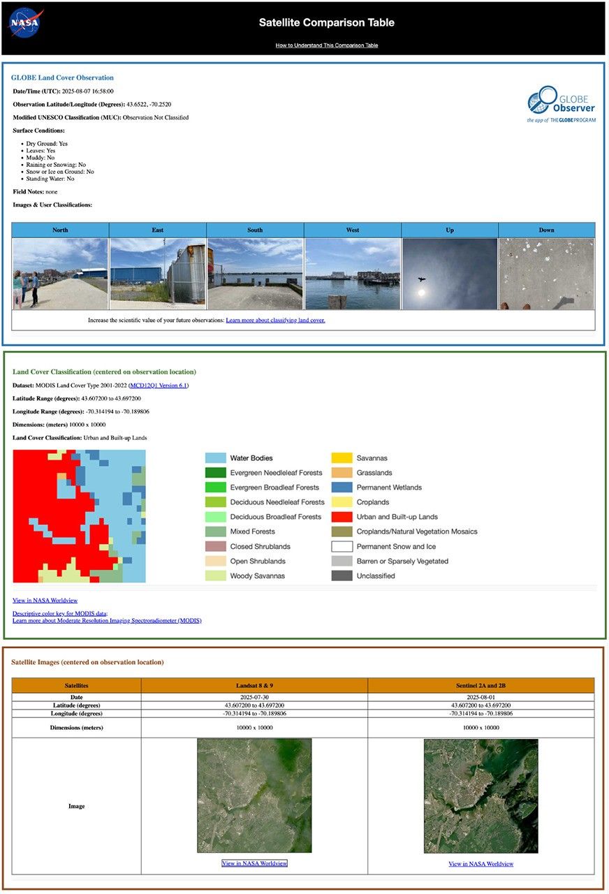
Data Collection: Improving the process of making and submitting land cover observations to NASA using the GLOBE Observer App. Curriculum Integration: Identifying connections between land cover observations, satellite data, and classroom learning. Student Research: Brainstorming potential land cover research topics/questions for students. Validation: Providing expert feedback on the satellite comparison process. Through GLOBE, communities can contribute meaningful environmental data to a long-term data record. When participants make observations of land cover via GLOBE Observer, the team at NASA Langley compares their observation with satellite data for a similar time and location and sends a satellite comparison email, which includes a data table that shows how their GLOBE observation and the corresponding satellite data compare.
Key Community of Practice Findings:
The Community of Practice included a total of 14 educators, with six actively collecting land cover observations with their students using the GLOBE Observer app. These land cover observations were collocated to MODIS, Landsat, and Sentinel-2 data with educators receiving a satellite comparison email.
Within the scope of this Community of Practice, 10 of the educators developed student research plans for the 2026-2027 school year focused on land cover data, addressing questions such as:
How does land cover affect surface temperature? How has land use changed over time for our local area? How does land cover differ for locations (such as other schools) at the same latitude but different longitudes? How do different land covers impact flooding? The educators were extremely excited to have the opportunity to interact and learn from each other as a community, as well as to connect with NASA subject matter experts. Based on lessons learned from the Community of Practice, the team has a better understanding of how NASA land cover data can be incorporated in the classroom, what types of research questions educators might present to their students, and resources that could be developed to assist educators in the implementation of their research plans.
Within the scope of the Land Cover Community of Practice (COP), educators were asked to provide feedback for the GLOBE Mission Earth GLOBE Nature Notes Guide that was developed by the NASA Langley team, leveraging the Nature Note model created by the NASA Science Activation program’s Learning Ecosystems North East (LENE) project, which is led by the Gulf of Maine Research Institute. The GLOBE Nature Notes aligned with GLOBE protocols were developed to assist educators in integrating the Nature Notes process with their students’ GLOBE observations. One of the COP educators is currently developing an example of a land cover GLOBE Nature Note that will be shared with the GLOBE and NASA Science Activation community, once completed.
Educators can join the GLOBE Program and contribute observations of Land Cover and other environmental conditions by downloading the GLOBE Observer app and learning more about Land Cover.
 Sample of a NASA GLOBE Observer satellite comparison table that gets emailed to a participant after submitting a land cover observation. (NASA Langley GLOBE Mission Earth Science Activation project team). NASA GLOBE Observer GLOBE Mission Earth is supported by NASA under cooperative agreement award number NNX16AC54A and is part of NASA’s Science Activation Portfolio. Learn more about how Science Activation connects NASA science experts, real content, and experiences with community leaders to do science in ways that activate minds and promote deeper understanding of our world and beyond: https://science.nasa.gov/learn/about-science-activation/.
Details Last Updated Jun 10, 2026 Related Terms Science Activation Earth Science Division
