CSDA Menu CSDA Commercial Data Commercial Datasets Commercial Satellite Data Explorer Satellite Data Evaluation CSDA Vendors Airbus U.S. BlackSky Capella Space GeoOptics GHGSat ICEYE Maxar Planet Polar Geospatial Center Spire Teledyne Brown Engineering Umbra Tomorrow.io PlanetiQ Program Activities Pilot Research Projects FAQs News Featured Articles 3 min read
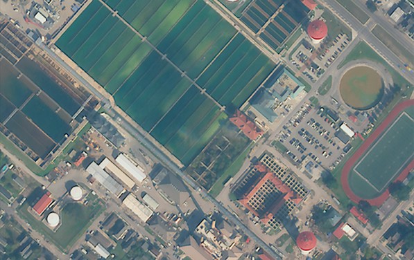
NASA’s Commercial Satellite Data Acquisition Program Releases Archived and Tasked Multispectral Data from Satellogic  This image of an urban area outside of New Orleans, Louisiana, shows the high resolution available from Satellogic’s level 1D Orthorectified multispectral archive and tasked data product now available in the CSDA Program’s Satellite Data Explorer. Credit: CSDA “The mission of the CSDA Program is to identify, evaluate, and acquire data from commercial sources that support NASA’s Earth science research and application goals,” said CSDA Project Manager Dana Ostrenga. “The addition of this product from Satellogic to the SDX demonstrates the CSDA Program’s ongoing commitment to that mission, as well as to our objective of bringing high-quality, Earth observation data from NASA’s commercial partners to the Earth Science community.”
This Level 1D product, which is equivalent to a NASA-defined Level 1C data product, is derived from satellites in Satellogic’s NewSat constellation, each of which carries a multispectral camera offering four bands in visible (red, green, and blue) and near-infrared part of the electromagnetic spectrum. The product provides images covering 25,000 square kilometers (km2) of the Satellogic archive.
Researchers interested in accessing this data product in SDX can use their Earthdata Login for authentication and initiate data download requests. The product includes all associated metadata and documentation, and its use is governed by the United States government plus End User License Agreement (USG EULA)
About SDX The SDX allows users to search, discover, and access a variety of Global Navigation Satellite System (GNSS), digital elevation model (DEM), synthetic aperture radar (SAR), multispectral, and precipitation radar data acquired through the CSDA program. It also provides streamlined data download, automated quota tracking, and a new coverage map that provides a high-level overview of the spatial coverage of the data discoverable through the SDX for any specified month and year. For a summary of the NASA commercial partner datasets available in SDX, visit the SDX website.
To order data from SDX, users must create an account with and be logged in to NASA Earthdata. (The initial attempt to use SDX will redirect users to Earthdata Login, where they will be prompted to enter their Earthdata credentials and accept the terms of the EULA.) Users must agree to the terms of the EULA before any data can be requested. Note: All data requests must be approved by CSDA data managers.
About the CSDA Program NASA’s Earth Science Division (ESD) established the CSDA Program to identify, evaluate, and acquire data from commercial providers that to support NASA’s Earth science research and applications. NASA recognizes the potential of commercial satellite constellations to advance Earth System Science and applications for societal benefit and believes commercially acquired data may also can augment the Earth observations acquired by NASA, and other U.S. government agencies, and NASA’s international partners.
All data from CSDA contract-awarded vendors are evaluated by the investigator-led CSDA project teams that assess the value of adding a vendor’s data to CSDA’s data holdings based on their quality and how they might benefit in the context of NASA Earth science research and applications. To learn more about the program, its commercial partners, data evaluation process, and more, visit the CSDA website.
Learning Resources For more information on the CSDA Program’s SDX, see the SDX user guide.
Detailed information about the Level 1D products is available on the Satellogic website.
Details Last Updated Jan 30, 2026 Related Terms Earth Science
 3 min read Extreme January Cold Following a significant winter storm, frigid temperatures lingered in late January 2026 across a vast…
Article
15 hours ago
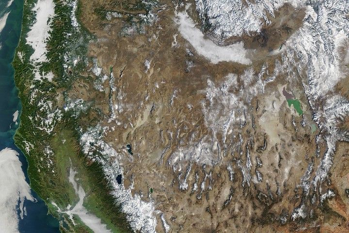 4 min read The West Faces Snow Drought Very wet—but very warm—weather in the western U.S. has left many mountainous regions looking at…
Article
2 days ago
 3 min read Students Across New England Contribute to Climate Science Through NASA’s GLOBE Green Down In fall 2025, more than 50 educators and over 1,500 young people across Maine and…
Article
1 week ago
Keep Exploring Discover Related Topics Missions


