3 min read
NASA Develops Process to Create Very Accurate Eclipse Maps New NASA research reveals a process to generate extremely accurate eclipse maps, which plot the predicted path of the Moon’s shadow as it crosses the face of Earth. Traditionally, eclipse calculations assume that all observers are at sea level on Earth and that the Moon is a smooth sphere that is perfectly symmetrical around its center of mass. As such, these calculations do not take into account different elevations on Earth or the Moon’s cratered, uneven surface.
For slightly more accurate maps, people can employ elevation tables and plots of the lunar limb — the edge of the visible surface of the Moon as seen from Earth. However, now eclipse calculations have gained even greater accuracy by incorporating lunar topography data from NASA’s LRO (Lunar Reconnaissance Orbiter) observations.
Using LRO elevation maps, NASA visualizer Ernie Wright at NASA’s Goddard Space Flight Center in Greenbelt, Maryland, created a continuously varying lunar limb profile as the Moon’s shadow passes over the Earth. The mountains and valleys along the edge of the Moon’s disk affect the timing and duration of totality by several seconds. Wright also used several NASA data sets to provide an elevation map of Earth so that eclipse observer locations were depicted at their true altitude.
The resulting visualizations show something never seen before: the true, time-varying shape of the Moon’s shadow, with the effects of both an accurate lunar limb and the Earth’s terrain.
“Beginning with the 2017 total solar eclipse, we’ve been publishing maps and movies of eclipses that show the true shape of the Moon’s central shadow — the umbra,” said Wright.
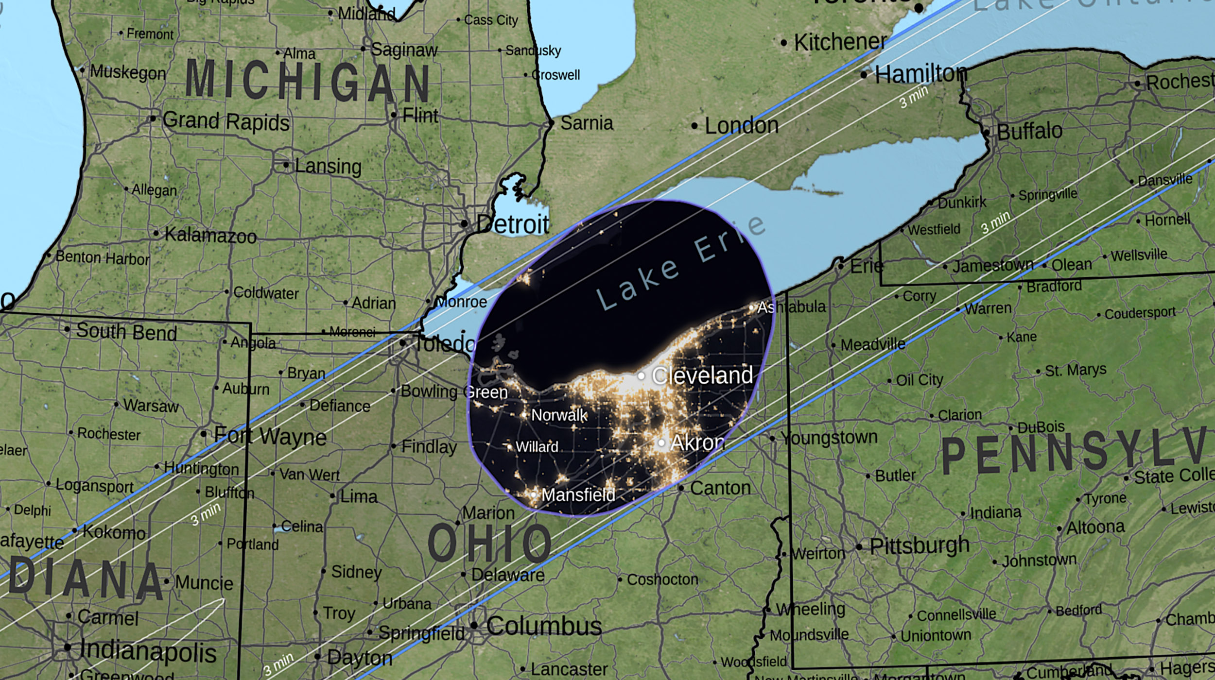
 A map showing the umbra (the Moon’s central shadow) as it passes over Cleveland at 3:15 p.m. local time during the April 8, 2024, total solar eclipse. NASA SVS/Ernie Wright and Michaela Garrison “And people ask, why does it look like a potato instead of a smooth oval? The short answer is that the Moon isn’t a perfectly smooth sphere.”
The mountains and valleys around the edge of the Moon change the shape of the shadow. The valleys are also responsible for Baily’s beads and the diamond ring, the last bits of the Sun visible just before and the first just after totality.
 A computer simulation of Baily’s beads during a total solar eclipse. Data from Lunar Reconnaissance Orbiter makes it possible to map the lunar valleys that create the bead effect. NASA SVS/Ernie Wright Wright is lead author of a paper published Sept. 19 in The Astronomical Journal that reveals for the first time exactly how the Moon’s terrain creates the umbra shape. The valleys on the edge of the Moon act like pinholes projecting images of the Sun onto the Earth’s surface.
 A visualization of Sun images being projected from lunar valleys that are acting like pinhole projectors. Light rays from the Sun converge on each valley, then spread out again on their way to the Earth. NASA SVS/Ernie Wright The umbra is the small hole in the middle of these projected Sun images, the place where none of the Sun images reach.
 Viewed from behind the Moon, the Sun images projected by lunar valleys on the Moon’s edge fall on the Earth’s surface in a flower-like pattern with a hole in the middle, forming the umbra shape. NASA SVS/Ernie Wright The edges of the umbra are made up of small arcs from the edges of the projected Sun images.
This is just one of several surprising results that have emerged from the new eclipse mapping method described in the paper. Unlike the traditional method invented 200 years ago, the new way renders eclipse maps one pixel at a time, the same way 3D animation software creates images. It’s also similar to the way other complex phenomena, like weather, are modeled in the computer by breaking the problem into millions of tiny pieces, something computers are really good at, and something that was inconceivable 200 years ago.
For more about eclipses, refer to:
https://science.nasa.gov/eclipses
By Ernie Wright and Susannah Darling
NASA’s Goddard Space Flight Center, Greenbelt, Md.
Media Contact:
Nancy Neal-Jones
NASA’s Goddard Space Flight Center, Greenbelt, Md.
301-286-0039
nancy.n.jones@nasa.gov
Details Last Updated Sep 19, 2024 Editor wasteigerwald Contact wasteigerwald william.a.steigerwald@nasa.gov Location NASA Goddard Space Flight Center Related Terms Goddard Space Flight Center Lunar Reconnaissance Orbiter (LRO) Solar Eclipses The Solar System
 4 min read NASA’s Webb Provides Another Look Into Galactic Collisions
Article
1 day ago
 4 min read NASA’s Hubble Finds More Black Holes than Expected in the Early Universe
Article
2 days ago
 4 min read Turn Supermoon Hype into Lunar Learning
Article
4 days ago